

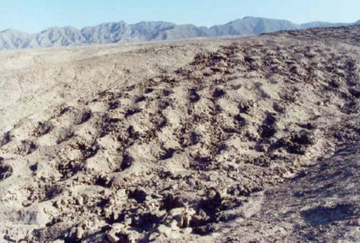
Across a dry slope in Peru, a long chain of carved gaps forms a line too orderly to dismiss as coincidence. Every opening appears ordinary on its own, but the full arrangement hints at a purpose that never reached written record. If ancient traces capture your curiosity, keep going and let each clue deepen the mystery.
Discovery Of The Band Of Holes
People first heard about the Band of Holes when, in 1933, National Geographic published aerial photographs taken by explorer Robert Shippee. The pictures showed thousands of small cavities lined across a hillside in Peru’s Pisco Valley. Their scale hinted at intentional work, suggesting many hands followed a shared plan, which raised early questions about how earlier groups organized labor and marked space.
Monte Sierpe, The “Serpent Mountain”
Locals call the formation Monte Sierpe because the row of holes winds over the slope like a long serpent. Its location in Peru’s dry southern foothills leaves the entire line exposed, almost impossible to miss. Such bold placement hints that ancient builders intended the holes to stand out, perhaps to steer foot traffic, set boundaries, or indicate moments of collective action.
Archaeological Evidence Of Market Origins
Archaeologists began to see a pattern once detailed mapping and closer field checks showed how the holes were arranged. Their even spacing and repeated clusters matched a layout suited for placing goods during short exchanges. The site sits between major regions, so both Chincha and Inca groups may have used these spaces during direct trade across the valley.
The Chincha People And Inca Expansion
Before the Inca Empire expanded, the Chincha managed wide trade routes along Peru’s southern coast. After the Inca absorbed them, tribute and labor duties shaped daily life. The neat rows of holes at Monte Sierpe may mirror this system, with each section acting as a marker, indicating which group owed goods and where their contribution belonged.
Numerical Rows And Khipu Connections
The holes follow numerical sequences that resemble the logic used in khipus, the knotted-string tools for recording quantities. A preserved khipu from the same valley shows a similar segmented rhythm. This resemblance prompted researchers to consider whether the landscape served as a large, physical counting system linked to local record-keeping traditions.
Future Research And Unanswered Questions
Many mysteries remain because no other archaeological place in the Andes shows a layout or scale similar to the Band of Holes. Researchers continue asking why this form appears only here and what specific tasks it supports. Each unanswered detail hints at ancient people using methods we still do not fully recognize, leaving room for future discoveries to reshape the story.
Drone Surveys And Structural Patterns
The wide gaps separating sections suggest a route meant for steady movement across the slope. Those pathways link blocks of holes, and every block follows a repeating sequence that feels deliberate rather than decorative. When viewed together, the layout points to an organized system that shaped how goods, duties, and groups moved through this older setting.
Tribute Collection And Accounting Systems
One possibility is that each section of holes represented a specific community responsible for delivering tribute. Historical lists from the sixteenth century show similar numerical organization. Items such as maize or woven textiles may have been placed in baskets inside the cavities for counting, with variations in row length reflecting population differences among towns.
Plant Traces And Basket Use
The idea of short-term storage at the site becomes clearer once you look at what remains inside the holes. Samples include maize, pollen, and plant material linked to weaving. These pieces suggest that baskets or bundled goods once rested in the cavities, leaving microscopic evidence of brief handling of items in this area.
Early Theories And Pseudoarchaeology
Researchers struggled to explain the holes because nothing in the region looked similar enough to offer guidance. Ideas included unused graves and storage pits, but physical checks ruled them out. Also, the area has no burial markers, human remains, walls, or traces of food. Their long, even rows instead pointed to activity shaped around gathering or movement.